 Hiking | Court of Ceremonies


Hype:
This trail is for the adventurous! It starts at marker #9 on the Parade of Rock Art Trail (#5) and takes you into a hidden canyon with exceptional the rock art. The trail is 0.5 miles and is steep, in places both up and down hill.
Trail Condition: Class 1 (Trail is either paved or gravel. Navigation skills are not needed because there is only one trail or because there are signs. Elevation gains are gradual or there are stairs.)
Time: 20-40 minutes
Length: 0.3 miles one way
Elevation Gain: 90 ft
Fees: Entrance fee
Recommended Ages:
 | 0-3 |
 | 4-11 |
 | 12-19 |
 | 20-49 |
 | 50-69 |
 | 70+ |
Recommended Months to Visit:
| Jan |
| Feb |
| Mar |
| Apr |
| May |
| Jun |
| Jul |
| Aug |
| Sep |
| Oct |
| Nov |
| Dec |
Navigate to 38.578384, -112.335182.
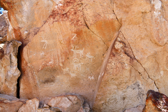
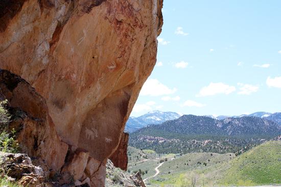
Look around you. From the place where you are standing three rock art panels are visible.
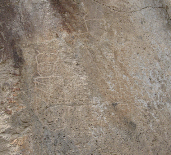
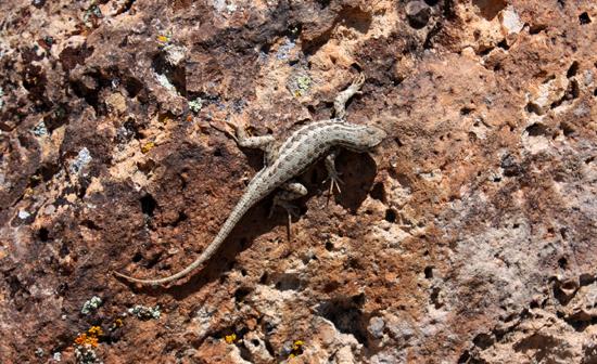
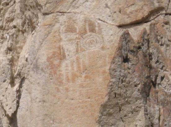
-To your left, the figure with two circles connected by a line is thought to be a map of the canyon that you are about to enter. The bottom shows two canyons coming together. That is where you are. The canyon then is straight as it goes through a rock slide. It then widens where the rock art is found. After the trail leaves the canyon, it narrows and then widens and then forks. Other figures include a lizard (below the map and to the right) and a possible hunting scene that includes the hunters. The crack in the rock may be the result of blasting done when 1-70 was built in the mid-1980's. The park staff monitors the cracks in attempt to save this irreplaceable panel.
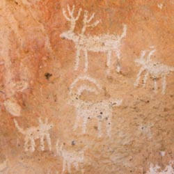
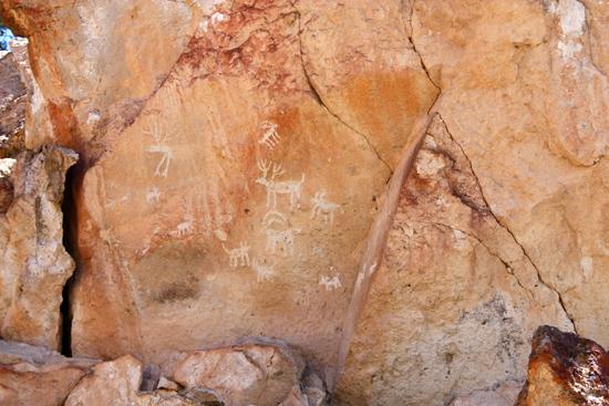
-To your right on the underside of the large rock is a hunting scene. This one is interesting because it shows pictures of deer in addition to the desert big horn sheep. Look at the size of the deer and their antlers. It is easy to understand why seeing a herd of animals this large would excite the Fremont enough to make them want to brag about their adventure and record it on the cliff so that they could relive it and share it with others.
-Look carefully and you can see a large human figure north of you on a flat rock at the top of the rockfall. The Paiutes say that this canyon was used for initiations, and that each panel was used to tell a different story that was used in the process of giving initiates instructions about manhood.
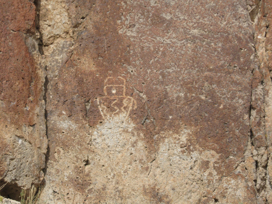
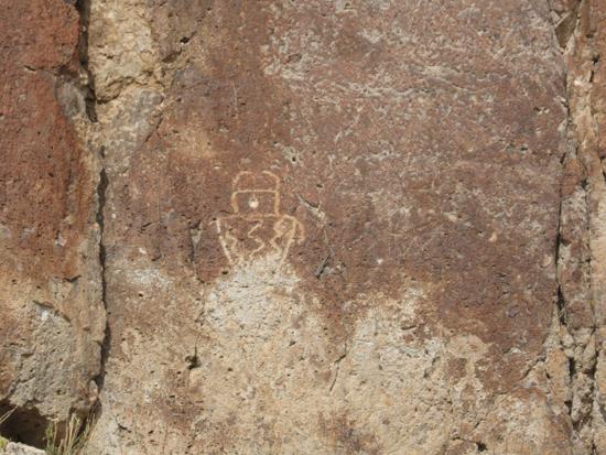
Just looking at these large human figures makes us wonder who these people were and why they were reproduced here as sentinels on these cliffs. The two-horned figures are thought to signify a god, medicine man or priest and also strength and power. Notice how they usually have no hands and legs and seem to be floating in the air. From looking at these figures we can learn about the Fremont clothing and jewelry. The necklace on the figure to the right was used as a model for the one made for Chikee, the sculpture on display in the visitor center. There are striking similarities between these petroglyphs and Fremont figurines. The size of the figure on the right is: 2' 8" by 1' 4". Now, with your eyes, follow the cliff to the right. How many other human figures do you see?
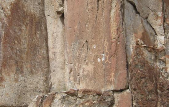
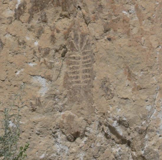
There is no known meaning or identification for the figure that looks like a trilobite. Through dubious research of local people on rock art and the Spanish Trail, it was thought that the panel was a skeleton and meant that a Spanish burial with gold was placed at the base of the cliff. In search for gold a hole was dug by unauthorized diggers. It is not known if anything was found in the hole. The area was divided into archaeological grids and systematically excavated under the parks direction as a training session for teachers in 1987-8. Although artifacts were found, there was no evidence of a Fremont burial or structure or of Spanish gold.
The faces of most of these large human figures are either blank or concentric circles. The single hole in this figure that makes it look like cyclops is from a bullet. This panel, like many others in Clear Creek Canyon, has withstood the elements for hundreds of years only to be damaged by vandalism. Man is the worst enemy of rock art. It is everyone's responsibility to preserve it, so that rock art can be enjoyed far into the future.
When the trail forks, near the ridge top, the Court of Ceremonies Trail goes to the right. The left fork connects to the Hidden Secrets Trail (#8).
The dominant vegetation on this ridge, as is true of much of Utah, is pinyon and juniper trees. These trees are usually found growing side by side, with a natural space around each tree and little ground cover.
The Colorado Pinyon (Pinus edulis) is usually the taller tree. It produces the pinyon nut early in the fall, which is a food that was highly favored by the Fremont and Paiutes and is easy to harvest (if you do not mind being sticky). The pinyon nut was usually stored after it was gathered, and then roasted. A mano and metate was used to grind the shelled nut into a highly nutritious and tasty meal that is used in a number of ways.
The tree with the gnarled branches and roots is the Utah Juniper (Juniperus osteosperma). The Fremont had many uses for almost all parts of the juniper. The wood was used to build pithouses and other structures and also fires. The bark was used in string, ropes and to make the insides of moccasins and cradles softer. The berry was used for dye and a medicinal tea. The berries were only used for food if little else was available. Today juniper wood is used for rot resistant fence posts and the berries are used for jewelry. It is ironic with Utah's liquor laws, that juniper is probably the most common tree in the state, and the only commercial use for it is flavoring gin. Places in Utah that are named after the cedar tree (Cedar City, Cedar Breaks, Cedar Fort, etc.) are actually named after the juniper.
Stop for a minute and enjoy the view. It is a good place to see the parks modern features like the visitor center, parking lot, cement sidewalks and 1-70. The Fremont also possibly used it as a viewpoint from which they could view their village on Five Finger Ridge, the rock art on the canyon wall to your right and the agricultural areas and trails in the canyon.
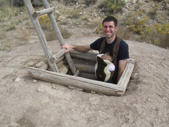
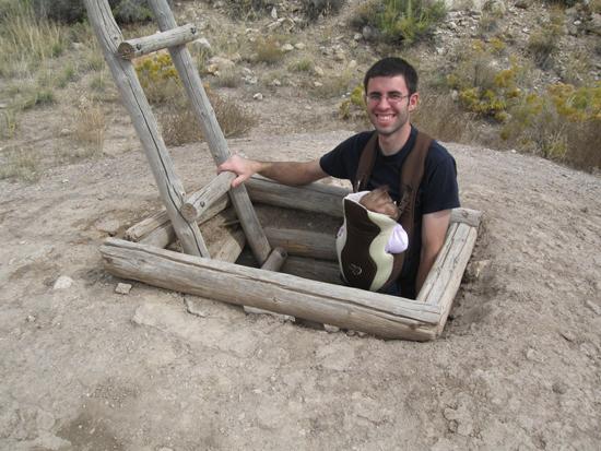
This pit house is copied from varying features of ones found on Five Finger Ridge. From excavation, the shape and size of pithouses and such characteristics as floors and firepits could be determined. More guesswork was involved in figuring out what the roof, smoke holes and ladders looked like. This pithouse only gives an idea of what one looked like. On Five Finger Ridge no two pithouses were identical in floor space or in the characteristics of the ventilator shaft or other features. This pithouse is empty. Look at the reconstructed pithouse in the museum to see what the Fremont put in them. You may go into the pithouse, but more than three people should not be on the roof at one time.

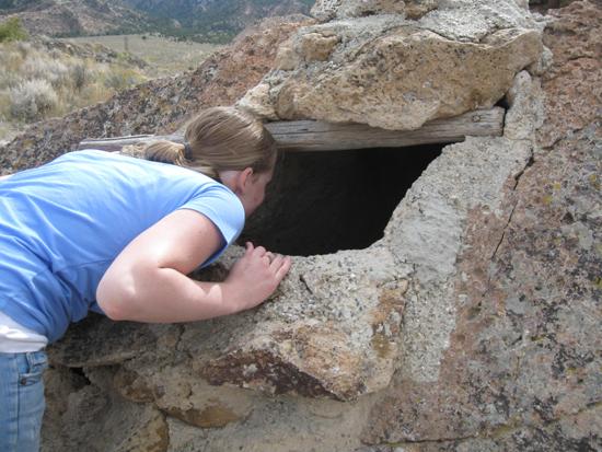
The Fremont stored their corn and other food in storage rooms called granaries. On Five Finger Ridge, of the 103 rooms excavated, nineteen were granaries. Another variation of the granary, like the one that this one was patterned after, is found throughout the cliffs of Clear Creek Canyon and its tributaries. Many of these are isolated and blend into the surrounding terrain and seem to be secret food caches that were hidden from others or enemies. Granaries are built air tight so that the food can be protected from rodents, insects and freezing. Please do not go into this structure or climb on its roof.
This is the last stop on the Court of Ceremonies Trail. We hope that you have just whetted your appetite for seeing rock art in the park! There is a lot more to see. Get information from the trail guide board or the information desk in the visitor center.
Closest City or Region: Fremont Indian State Park, Utah
Coordinates: 38.578384, -112.335182
By Jeremy Dye
Jeremy Dye, Tara Dye, Savannah Dye, Greg Dye, Laura Dye, Ondylyn Wagner, Zac Dye,

By Jeremy Dye
Jeremy Dye, Tara Dye, Savannah Dye,
We picked up a trail guide at the visitor center and hiked around several of the trails in the park.

Geology of Fremont Indian State Park
 Petroglyphs and Pictographs