

Hype:
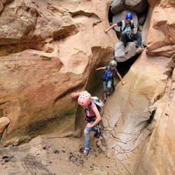
Watson Canyon, located near Torrey, Utah, offers a moderate canyoneering adventure in a scenic desert setting. This canyon features several downclimbs and potentially a few short rappels, depending on conditions and the skill level of the group. The approach is relatively quick, and the exit, a miserable slog straight up a steep and loose canyon wall, provides sweeping views of the surrounding red rock landscape. The canyon is typically dry. While it lacks the dramatic features of other nearby canyons, Watson Canyon provides a pleasant outing for those seeking a more relaxed canyoneering experience near Capitol Reef National Park. Reaching the trailhead requires a true high clearance 4x4 and skilled driving. The drive looks short on a map, but it takes about 45 minutes each way from the pavement.
Time: 2-3 hours
Length: 0.54 mile approach, 0.55 miles in canyon, 1.1 mile exit
Longest Rappel: 1-3 rappels to 65 ft
Gear: Standard canyoneering gear.
Fees: None
Recommended Ages:
 | 0-3 |
 | 4-11 |
 | 12-19 |
 | 20-49 |
 | 50-69 |
 | 70+ |
Recommended Months to Visit:
| Jan |
| Feb |
| Mar |
| Apr |
| May |
| Jun |
| Jul |
| Aug |
| Sep |
| Oct |
| Nov |
| Dec |
Links: https://www.roadtripryan.com/go/t/utah/capitol-reef/watson-canyon
Navigate to 38.360809, -111.440708.
Although the trailhead is only a few miles from Torrey, plan on at least 45 minutes of true high clearance roads. This road is popular with ATVers for good reason.
From the trailhead, follow an old dirt road southeast for 0.4 miles. Leave the road and turn north to drop down a short but steep slope into Watson Canyon.
Once inside the canyon, you'll encounter a handful of straightforward obstacles, including small downclimbs and up to 3 rappels, the most significant being around 65 feet.
Drop. 65 ft rappel from a slung boulder anchor.
Drop. 15 ft rappel from a slung boulder anchor. Can be downclimbed.
Drop. 25 ft rappel from a slung boulder anchor. Can be downclimbed.
The exit is a little tricky to find. If you leave the canyon too early, you get cliffed out after climbing 50 ft or so. Make sure you climb the ridge up. The initial climb out of the canyon to the rim gains 350 ft of elevation in a little over 0.1 miles. The ground is loose, so it's a bit of a push to get up the hill. Once on the rim, the trail turns to a gradual uphill hike up the dirt road and back to the trailhead. Total exit is a little more than a mile.
By Jeremy Dye
Jeremy Dye, Tara Dye, Savannah Dye, Madilyn Dye, Cooper Dye, Matt Laurendeau, Amanda Laurendeau, Alex Laurendeau, Caleb Laurendeau, Rose Laurendeau, Lila Laurendeau, Trey Laurendeau,
Trailhead: 10:25
Top of Watson Canyon: 10:50
Bottom of Watson Canyon: 2:10
Trailhead: 3:55
We got a little bit later start but still hit our canyon at a decent time in the morning. We did Watson Canyon, which was up the really bad dirt road. Since the Laurendeaus' van couldn't make it up the road, we packed all the gear and 12 people into our truck and drove up to the trailhead. It took us most of an hour to drive a couple miles. The road was super rough with lots of round bumpy rocks that we had to drive over. They were also sections of slick rock shelves that we had to make our way up. Matt was in the back with the kids and did not appreciate the rough ride.
The approach to Watson Canyon was awesomely short, and we tried to sequence as much as we could and spread out in the canyon, so we weren't bottlenecked. We still ended up getting bottlenecked a little bit toward the end, but it wasn't too bad. The biggest bottleneck was where there was a pond that we ziplined people over. A few competent canyoneers could do the canyon quite quickly because most of the drops were downclimbable, but for our group, we rappelled most of the drops. Once we finished the canyon, we exited up the nasty steep exit hike and got cliffed out early on. We were knocking huge loose rocks down on other people, and it was very scary. We did eventually find our way up and did the slog up to the rim. I carried Trey in my backpack. Matt carried Lila on his shoulders. By the end of that, his back was hurting pretty bad. Then we still had most of a mile of road walking to get back to the truck. The littlest kids and Cooper were dragging, but we all made it eventually. Then we took the nasty bumpy road back to camp.
 Sand Creek GWT Trailhead Primitive Camping
Monroe Canyon First Lefthand Fork Primitive Camping 1
Monroe Canyon First Lefthand Fork Primitive Camping 2
Oak Creek Recreation Site / Campground
Sand Creek GWT Trailhead Primitive Camping
Sheep Valley Primitive Camping
Upper Box Creek Reservoir Camping
Loop Hike from Puffer Lake around Lake Peak
Paddling Upper Box Creek Reservoir
Sand Creek GWT Trailhead Primitive Camping