

Hype:
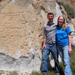
This panel is thought by the Paiutes to represent the circle dance, which they perform to request rain. The Hopi claim agreement saying that the Fremont were depicting a rain seeking ceremony that was practiced at the time by the Hopi and is still performed with many of the same characteristics today. The ceremony that the panel portrays is called the Marao ceremony which means leg painting in Hopi. It shows women with their legs banded (shown as circles connected by lines) dancing in a circle holding cornstalks in the air and spreading pollen on the ground. The ceremony is performed at harvest time and is thought to be a plea for rain for the next spring. This panel is thought to have been put here, where it is difficult to see from Clear Creek canyon, because it fits within the theme of other rock art in the Canyon of Life.
Go east and stop in the middle of the canyon.
Life on the earth came from two women who lived there alone. It was the custom of the woman dwelling in the Pacific to go outside each morning and lie down with her legs spread wide apart opening herself toward the rising sun, the woman dwelling in the Atlantic went outside each evening to lie down with her legs spread wide apart opening herself toward the setting sun. For each of the women the sun, Tavapitsi, by a sudden concentration of his rays caused them to conceive and have children.
The Hopis and Paiutes believe that this canyon is shaped the way that it is to tell the story of how life came to the earth through conception from the sun. Other than the mouth, the canyon has three natural openings. One in the center; one on the west side (just behind the Marao Panel) and one on the east side. The west opening represents the woman dwelling in the Pacific and the east opening represents the woman dwelling in the Atlantic. They are both lying with their legs spread far apart toward the rising or setting sun. The hole that is in the east opening is a natural tunnel.
The next stop is the rock art panel on the east side of the canyon.

This panel is thought to explain the meaning of the shape of this canyon as being the legend about life being conceived from the sun from the east and west. In the panel, the features of the canyon and the sun shining on them from the east and west is shown by the mirroring y-shaped shaped figures at the top. The wavy line over the right figure shows that it came from the sea. The sun is shown with its converging rays on the right of the panel. The hole in the center is the natural tunnel in the east opening. It is at the end of a shaft to show that the sun penetrated the hole, and as a result, life was conceived. The figure at the far right is thought to represent life coming to the land. There is still much to be learned about this panel. In 1998, it was discovered that on the summer solstice, at noon, the sun casts a dagger of light from the center of the hole through the outer rim of the circle. This means that the panel was placed at this specific location to correspond with this phenomena. It is important that this panel not be altered in any way. Please do not touch it or climb on the rock above it.

In addition to the panel just described. There are 28 other Fremont panels located nearby to the south and east. Follow the trail going toward the frontage road and see how many of them you can find. See if you can spot the panel with the:
We hope that you enjoyed seeing such a wide variety of rock art, undamaged and preserved. Please help us continue to offer the same experience to others.
Go toward the middle of the canyon to a flattened grassy area.
In 1922, two brothers by the name of Olcott came from Beaver to Clear Creek canyon to live. One of the brothers, Robert, lived here with his wife and four children. You are now standing near the location of the wooden home that he built. Up canyon, to the north, is the remains of the Olcott's potato pit. From 1947 until 1-70 was started, the area was owned and used as a corral by ranchers Ted and Catherine Harps. They built a second wood building, east of the first that they used to do lapidary work. Both structures burnt in 1986. Mr. Harps claimed to have found a Fremont pithouse when he was doing work to enlarge the potato pit.
This is the final stop on the Canyon of Life Trail. Please return to your car by going by the trailhead.
Trail Condition: Class 2 (Trail may have tree roots or rocks jutting out. Navigation skills may consist of following rock cairns and choosing turns at junctions. Elevation gains may be more substantial.)
Time: 20 minutes
Length: 0.2 miles round trip
Elevation Gain: 60 ft
Fees: Entrance fee
Recommended Ages:
 | 0-3 |
 | 4-11 |
 | 12-19 |
 | 20-49 |
 | 50-69 |
 | 70+ |
Recommended Months to Visit:
| Jan |
| Feb |
| Mar |
| Apr |
| May |
| Jun |
| Jul |
| Aug |
| Sep |
| Oct |
| Nov |
| Dec |
Navigate to 38.576645, -112.345200.
Closest City or Region: Fremont Indian State Park, Utah
Coordinates: 38.576645, -112.345200
By Jeremy Dye
Jeremy Dye, Tara Dye, Ondylyn Wagner, Zac Dye,
15 minutes
We had a fun time looking at the interesting rock art.
Geology of Fremont Indian State Park