

Hype:
The Icebox Foot Trail is a short hike up to a spring at the base of a short canyon. The canyon is very shaded and cool, which leads to the name.
Trail Condition: Class 1 (Trail is either paved or gravel. Navigation skills are not needed because there is only one trail or because there are signs. Elevation gains are gradual or there are stairs.)
Time: 15 minutes
Length: 0.2 miles round trip
Elevation Gain: 50 ft
Fees: None
Recommended Ages:
 | 0-3 |
 | 4-11 |
 | 12-19 |
 | 20-49 |
 | 50-69 |
 | 70+ |
Recommended Months to Visit:
| Jan |
| Feb |
| Mar |
| Apr |
| May |
| Jun |
| Jul |
| Aug |
| Sep |
| Oct |
| Nov |
| Dec |
Navigate to 38.835608, -110.810253.
Even though it looks close to I-70, it's actually an 11-mile drive on dirt roads to reach the Icebox Foot Trail. From I-70, take exit 131 for Sinbad Road and head south. I'm not going to detail out the turn-by turn navigation on how to get there, but I've shown the approach drive on the map below.
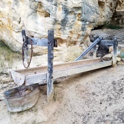
From the trailhead, follow the short foot trail to the south. You will soon pass and old trough used for collecting water from the spring. Continue a short distance further to the mouth of a short, shaded canyon.
Closest City or Region: San Rafael Swell, Utah
Coordinates: 38.835608, -110.810253
By Jeremy Dye
I stopped and visited Swasey Cabin on my way to do some canoneering for the weekend. After looking around at the cabin, I took the little foot trail down to the road then walked down the road to the trailhead to Icebox Canyon. I walked up to Icebox Canyon, checked out the relics, then walked back up the road to the parking area. I ran into a guy that was just exploring around. He didn't really know where he was or where he wanted to go. He just had a map and was driving around to places that were listed on the map. That was really weird to me because I like to do a lot of research before any of my trips.
Green River State Park Campground