 Hiking | Mount Whitney


Hype:
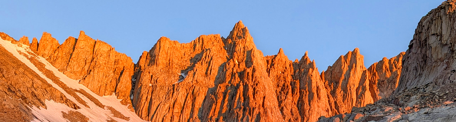
The Mount Whitney hike in California is a bucket-list adventure that takes hikers to the summit of the tallest peak in the contiguous United States, standing at 14,505 feet. This 22-mile round-trip trail begins at Whitney Portal and ascends over 6,100 feet through breathtaking alpine scenery, including granite cliffs, pristine lakes, and high-altitude meadows. Known for its challenging switchbacks, including the infamous 99 Switchbacks, and its thin air at high elevations, the hike requires excellent fitness and preparation. Permits are required due to its popularity, and many hikers complete the journey in a single grueling day, while others opt to camp overnight. The reward for reaching the summit is unmatched: panoramic views stretching across the Sierra Nevada, Owens Valley, and beyond. It’s a true test of endurance and determination, making it one of the most iconic hikes in the country.
Trail Condition: Class 3 (Trail may have sections where hands are needed. Trail may not be visible in spots or may not exist at all.)
Time: 1-2 days
Length: 22 miles round trip
Elevation Gain: +7345 ft, -1,219 ft
Fees: Reservations
Recommended Ages:
 | 0-3 |
 | 4-11 |
 | 12-19 |
 | 20-49 |
 | 50-69 |
 | 70+ |
Recommended Months to Visit:
| Jan |
| Feb |
| Mar |
| Apr |
| May |
| Jun |
| Jul |
| Aug |
| Sep |
| Oct |
| Nov |
| Dec |
Links: https://www.alltrails.com/trail/us/california/mount-whitney-via-mount-whitney-trail
Navigate to 36.586886, -118.240012.
The Mount Whitney hike begins at Whitney Portal Trailhead (elevation 8,360 feet), located 13 miles west of Lone Pine, California. From the trailhead, the well-marked path gently ascends through a pine forest along the banks of Lone Pine Creek. Within the first few miles, you’ll pass beautiful streams, waterfalls, and lush meadows, with plenty of opportunities to enjoy the scenic surroundings.
Around Mile 3, you’ll reach the junction with the North Fork of Lone Pine Creek. Continuing on the main trail, you’ll begin climbing more steadily, entering the open granite landscape. By Mile 6, you’ll arrive at Trail Camp (12,000 feet), a popular spot for overnight campers. Trail Camp features a small alpine lake, known as Consultation Lake, and is the last place to refill water before the summit. From here, the trail transitions into a more challenging section.
The ascent from Trail Camp includes the infamous 99 Switchbacks, a grueling stretch that climbs nearly 1,800 feet in about 2 miles. This portion is exposed, with breathtaking views but no shade, making an early start essential. At the top of the switchbacks, you’ll reach Trail Crest (13,600 feet), the highest point on the trail before the summit.
From Trail Crest, the trail traverses a narrow ridge with steep drop-offs, offering spectacular views of the Owens Valley to the east and Sequoia National Park to the west. The final 2 miles include a series of rocky climbs and descents. This section is more rugged, with some scrambling over large granite boulders. The thin air at this altitude can make the climb feel significantly harder.
The trail culminates at the Mount Whitney Summit (14,505 feet), marked by a stone hut built in 1909. From the summit, you’ll be rewarded with panoramic views of the Sierra Nevada, the Inyo National Forest, and the expansive Owens Valley far below. After soaking in the views, you’ll retrace your steps back to Whitney Portal. Most hikers take between 12 to 18 hours to complete the round trip, making it a long and demanding but unforgettable experience.
Note that afternoon thunderstorms are frequent on Mount Whitney, so you'll want to get an early start so you can reach the summit by noon.
Closest City or Region: Sierra Nevadas, California
Coordinates: 36.578499, -118.292260
By Jeremy Dye
Tara Dye, Ondylyn Wagner, Marci Parker, Others,
Tuesday, June 25 - Tara and group packed up camp. They had a short day of hiking, so they took it easy and started hiking around 9:00. They hiked until 1:00, when they set up camp at Outpost Camp. They had plenty of time and energy to keep going, but the weather forecast showed rain. They set their tents up just in time because it rained for the next 4 hours. Luckily Tara had a movie download on her phone, so she and Ondy watched that in their tent while they waited out the storm. Near the end of the rain storm, the river overtopped the bank upstream of them and flooded their tent spot. They had to relocate to higher ground. They fixed dinner, hung out, and went to bed.
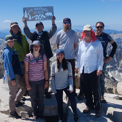
Wednesday, June 26 - Everyone except Ondy and Tara started hiking at 3:15 a.m. Ondy and Tara started a half hour later because they were faster hikers. They made it up to the summit of Mount Whitney by 10:00 California time.
Surprisingly they had cell signal at the peak. They then hiked all the way back to the trailhead, stopping and picking up their overnight gear along the way. Ondy, one other person, and Tara made it back to the cars by 7:00 p.m. The rest of the group finished about an hour after that. They set up camp at the Mount Whitney Campground. Thursday, June 27 - Tara drove home from California. She got home around 8:00 p.m.
Congress Trail to General Sherman Tree
Tokopah Valley Trail to Tokopah Falls
 Hiking Trails
 Mountains
 Waterfalls
 Rivers and Streams
 Lakes and Reservoirs
 Forest
 Non-potable Water - filterable
 Marked Trails
 No Restrooms
 Road Access is Paved
 Access Road is 2WD Accessible
 Viewpoint, Overlooks, Vistas
 Wildflowers and Vegitation
 Wildlife and Birding

