

Hype:
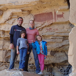
Farnsworth Canyon is a fun, family friendly hike through a non-technical slot canyon in the San Rafael Swell. The hike passes a well-preserved pictograph panel featuring three extra tall people and several animals. Access to the trailhead requires a high clearance vehicle.
Trail Condition: Class 2 (Trail may have tree roots or rocks jutting out. Navigation skills may consist of following rock cairns and choosing turns at junctions. Elevation gains may be more substantial.)
Time: 1-2 hours
Length: 2.8 miles round trip
Elevation Gain: 150 ft
Fees: None
Recommended Ages:
 | 0-3 |
 | 4-11 |
 | 12-19 |
 | 20-49 |
 | 50-69 |
 | 70+ |
Recommended Months to Visit:
| Jan |
| Feb |
| Mar |
| Apr |
| May |
| Jun |
| Jul |
| Aug |
| Sep |
| Oct |
| Nov |
| Dec |
Navigate to 38.666411, -110.615088.
At the junction of Temple Mountain Road and Goblin Valley Road is a large kiosk with an area map. From the pullout, take the dirt road northeast for 2.5 miles to the trailhead. This road is not maintained, and a high clearance vehicle with four-wheel drive is recommended.
From the trailhead, follow a well-traveled trail northwest until it enters the wash. Follow the wash up through a section of slot canyon. Once the canyon opens up, continue to follow the main drainage northwest. A cairn marks the pictograph panel location.
Closest City or Region: San Rafael Swell, Utah
Coordinates: 38.669629, -110.616617
By Jeremy Dye
Jeremy Dye, Tara Dye, Savannah Dye, Madilyn Dye, Cooper Dye, Anthony Dye, Arianne Dye, Miller Dye, Ondylyn Wagner, Jaren Wagner, Killian Wagner, Marci Parker, Shawn Parker, Callie Parker, Wade Parker, Aria Parker, Lillian Parker,
Start hiking 11:10
Arrive at pictograph panel: 12:10
Back at trailhead: 1:45
Due to all the recent rain and after our experience in Ding and Dang Canyons, we opted for a dry hike on Saturday. We chose Farnsworth because it was dry and easy for all the kids. By coincidence, we ran into Jaren at the kiosk who just happened to be there at just the right time to meet up with us. We drove out to the trailhead but misunderstood the driving directions. Instead of driving 2.5 miles total from the kiosk, we drove 2.5 miles past the previous wash, which took us about a mile past the trailhead. That last mile was really rough, and we ended up getting the truck stuck for a few minutes dropping down into a wash. We got the truck unstuck and turned around and and arrived at the trailhead shortly after 11. We hiked up the wash and enjoyed the easy hiking and the cool slot canyon section. We weren't aware of the arches until after our hike, so we missed those, but we enjoyed scrambling up to see the pictograph panel. We stopped and had some snacks and chilled for a bit, then we hiked back down to the cars.
Goblin Valley Primitive Camping
Quandary Trailhead Primitive Camping
Temple Mountain Road Primitive Camping
Goblin's Lair Canyoneering Route
Temple Mountain Wash Pictograph Panel