

Hype:
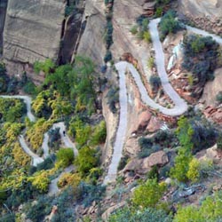
Angels Landing is an awesome hike that I would recommend to everyone that has a chance to go. The trail is very steep and tiring, but the view at the top is worth it. The last portion of the hike is especially breath-taking with 1000-foot cliffs that drop off from both sides of the trail.
Trail Condition: Class 2 (Trail may have tree roots or rocks jutting out. Navigation skills may consist of following rock cairns and choosing turns at junctions. Elevation gains may be more substantial.)
Time: 2-5 hours
Length: 4.2 miles round trip
Elevation Gain: 1,510 ft
Fees: Entrance fee
Recommended Ages:
 | 0-3 |
 | 4-11 |
 | 12-19 |
 | 20-49 |
 | 50-69 |
 | 70+ |
Recommended Months to Visit:
| Jan |
| Feb |
| Mar |
| Apr |
| May |
| Jun |
| Jul |
| Aug |
| Sep |
| Oct |
| Nov |
| Dec |
Navigate to 37.259407, -112.950645.
Most of the trail is paved. The first part of the Angels Landing trail is switchbacks. Some parts of the trail are carved into the rock face. At the top of the first series of switchbacks, the trail turns left, crosses a bridge, and enters a shady canyon. This part of the trail is mostly flat as it follows a dry river bed.
The next section of trail is a series of extremely steep switchbacks. At the top of the switchbacks, the paved trail ends. This is Scout Lookout.
The trail splits. To the left is West Rim Spring (on the West Rim Trail), and to the right is Angels Landing.
You'll soon come to this sign warning you of the dangers ahead:
Angels Landing
- Strenuous climb
- Narrow route with cliff exposures
- Hazardous during thunderstorms, darkness, and ice/snow conditions
And as if that weren't enough, they put up another sign warning you to turn back:
Since 2004, __ people have died falling from the cliffs on this route. The 1.1-mile (1.8-km) round-trip route from Scout Lookout to Angels Landing is a strenuous climb on a narrow ridge over 1,400 feet above the canyon floor. This route is not recommended during high winds, storms, or if snow or ice is present.
This is where the fun part begins. The trail passes over sandstone slickrock, which cliffs on both sides. Zion National Park has been kind enough to install handrails with chains in the sketchier places. Groves in the sandstone where people have walked are evidence that Angels Landing is a popular hike. This is my favorite part of the hike. The trail narrows to about 6 feet across as you hike up the ridge.
Closest City or Region: Zion National Park, Utah
Coordinates: 37.269570, -112.948239
By Jeremy Dye
Tara Dye, Todd Coons, Loreen Coons, Brittany Coons, Aubrey Coons, Caleb Coons, Lawson Burnett, Meguire Burnett, Amy Mears,
3.5 hours
A bunch of family hiked Angel's Landing as part of the 2017 Burnett family reunion.
By Jeremy Dye
On October 21, 2011 Tara and I hiked Angels Landing after completing Pine Creek Canyon. We got off the bus at about 5:15 pm.
As we were nearing the top, it started getting too dark to continue. The only flashlight we had was my phone, and we didn't want to be on the exposed cliffs in the dark, so we turned back less than a quarter mile from the top. Even though we weren't all the way to the top, the views were amazing.
When we made it back to the trailhead, just past the bridge, we ran into several deer. When I shined my flashlight at them, they just stood there staring at it. It was pretty fun to be only a few feet away from them.
By Jeremy Dye
Jeremy Dye, Hobble Creek 4th Ward Young Men,
The following pictures are from my trip in August 2001. We went as a young men group.
Hidden Canyon (Technical Route)
Kolob Reservoir Primitive Camping
Hidden Canyon (Technical Route)
Flaming Gorge National Recreation Area
Little Black Mountain Petroglyph Site
St. George Dinosaur Discovery Site at Johnson Farm
Zion National Park Visitor Center