

Hype:
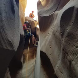
Blue Pool Wash is a fun little canyon near Lone Rock Beach. With basically no approach, this canyon sees a lot of visitors. There are 3 drops that can be rappelled. Although all of the drops are technically downclimbable, most people will choose to rappel at least the 50-foot drop. The last rappel is particularly photogenic. Blue Pool Wash can sometimes hold water, but it is often dry.
Time: 1-2 hours
Length: 1.5 miles round trip
Longest Rappel: 50 ft
Gear: Standard canyoneering gear.
Fees: None
Recommended Ages:
 | 0-3 |
 | 4-11 |
 | 12-19 |
 | 20-49 |
 | 50-69 |
 | 70+ |
Recommended Months to Visit:
| Jan |
| Feb |
| Mar |
| Apr |
| May |
| Jun |
| Jul |
| Aug |
| Sep |
| Oct |
| Nov |
| Dec |
Links: https://www.roadtripryan.com/go/t/utah/powell/blue-pool-wash
100 yards. From the parking area, head northwest and pass through the gate. Remember to close it behind you! In a minute or two, you'll arive at the top of Blue Pool Wash.
0.63 miles. Proceed down canyon and down a short drop, then pass under Highway 89. You'll soon arrive at a 10-foot downclimb with the remains of a car at the base of the boulder stack. Keep going down canyon a few more minutes to two more drops. The first one is a 10-foot drop that can be rappelled or downclimbed. The next drop can also be rappelled, but the downclimb is quite easy if you climb down the hole between the chockstones.
Continue down canyon for another five or so minutes to the top of a 50-foot drop. There are some huge chains and 4 bolts at this drop. Rappel 50 feet or you can downclimb this drop. Follow the wash down to the bottom of Blue Pool Wash. If you're feeling especially adventurous, about 1/8th of a mile after the last rappel, you can hike up the drainage that comes in from the south. This canyon quickly narrows, and you'll can stem up canyon to a large room surrounded in cliffs. There's no safe way to ascend this canyon, so you'll have to return to the main wash and exit the standard way.
0.75 miles with 250 feet of elevation gain. From the bottom of Blue Pool Wash, follow the base of the cliff southeast until you can climb up a slickrock gullie. You'll gain 99% of the elevation in the first tenth of a mile. Then once you make it up to the top of the plateau, follow a well-traveled trail southwest back to your vehicle.
Closest City or Region: Glen Canyon National Recreation Area
Coordinates: 37.038603, -111.618400
By Jeremy Dye
Jeremy Dye, Tara Dye, Ondylyn Wagner, Shawn Parker, Marci Parker, Becca Bevan,
After doing Wildcat Tank Canyon, we headed over to Blue Pool Wash for our second canyon before lunch. We dropped in west of Highway 89 and proceeded down canyon. We were very disappointed to see so much graffitti on the walls. I think because it it so close to Lone Rock Beach and is mostly non-technical, it attracts a lot of people that either don't know or don't care about canyoneering ethics. We scrambled down the first drop quite easily. The drop where we had to wriggle through the hole between the rocks was also quite easy for everyone, except Shawn had an amusing time with his long legs. When we got to the drop with the bolts and chains, everyone in the group rappelled down except I downclimbed it with a fireman belay. Once we got to the bottom of the canyon, we decided to exit up the south fork because it looked more fun than the standard exit. We stemmed up canyon to the head of the canyon, which opened into an ampitheater with no obvious way up to the rim. We tried a couple of routes up the wall that had a ton of pockets in it, but it was too exposed and would have required several human pyramids. We were positive we could climb back down if we tried, so we retreated back down canyon through the stemming section to the traditional exit. By the time we completed the exit and got back to the car, it was getting really hot out, so we headed over to Lone Rock Beach to cool off in the lake.
Camping at Halls Creek and Millers Creek Confluence
Escalante River Primitive Camp 1
Escalante River Primitive Camp 2
Fence Canyon Primitive Camping
Iceberg Canyon Primitive Camping
Navajo Canyon Primitive Camping
Stud Horse Point Primitive Camping
Baboon Laughs Canyon (aka Laughing Baboon Canyon)
Poe Canyon (aka Smiling Cricket Canyon)
Early Weed Bench to Escalante River
Escalante River to Early Weed Bench
Lee's Ferry Historic District River Trail
Navajo Bridge Interpretive Center
Stud Horse Point Primitive Camping
Vermilion Cliffs National Monument
Buckskin Gulch and Paria Canyon from Wire Pass to Lees Ferry
Lee's Ferry Historic District River Trail