

Hype:
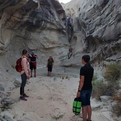
A short non-technical canyon hike just north of Page, AZ. While the canyon has no rappels, the entry downclimb and some zero exposure stemming keep things a bit interesting, though this might keep it from being an entirely "family-friendly" walk-through canyon.
Time: 1 hour
Length: 1.5 miles round trip
Longest Rappel: N/A
Gear: Helmet. Some may want a short rope for a handline.
Fees: None
Recommended Ages:
 | 0-3 |
 | 4-11 |
 | 12-19 |
 | 20-49 |
 | 50-69 |
 | 70+ |
Recommended Months to Visit:
| Jan |
| Feb |
| Mar |
| Apr |
| May |
| Jun |
| Jul |
| Aug |
| Sep |
| Oct |
| Nov |
| Dec |
Navigate to 37.001394, -111.594824.
Drive as far down the dirt road as you're comfortable. When it gets rough, put it in park and start walking.
0.55 miles with 130 feet of elevation loss and then gain. Hike northwest to the head of the canyon. Cross a couple of shallow washes on the way.
Right at the head of the canyon, there is a 15-foot chute downclimb. It is not difficult, but some more timid canyoneers may want a rope for a handline. Walk 0.4 miles to the bottom of the canyon. There are no additional obstacles.
Head south-southeast for 0.5 miles until you reach the parking area. Elevation loss/gain is minimal.
Closest City or Region: Glen Canyon National Recreation Area
Coordinates: 37.003730, -111.602079
By Jeremy Dye
Jeremy Dye, Tara Dye, Ondylyn Wagner, Shawn Parker, Marci Parker, Becca Bevan, Luke,
After we got situated at camp, we did a short night hike through Stud Horse Point Canyon. We knew it was a pretty easy canyon from the beta, so we packed pretty light. We took a short rope for a handline just in case we needed it for the downclimb. As we were starting hiking, we met up with a guy who was out exploring around. We found out his name was Luke and that he was working in Page for the summer and was looking for some hiking spots. We invited him to join us, so he grabbed a head lamp and came along. We walked up to the head of the canyon and dropped in. The downclimb at the head of the canyon was very doable without a rope. We walked down the canyon and arrived at the bottom very quickly. Not wanting our adventure to end to quickly, we challenged ourselved to escape up a side drainage to the north. We did a 3-level human pyramid with Shawn at the bottom, me in the middle, and Ondy at the top. Once Ondy got up, we fixed a rope and everyone else climbed up. Once we were up on the rim, we walked over to the next drainage to the north. The head of that canyon had a mandatory rappel, and we didn't have harnesses with us. I thought about handlining down but decided against it, so we all rim-walked along the north rim of that canyon. We soon came to a little drop in the rim where we were able to wrap the rope around a rock horn and batman down into the canyon. About half the group climbed down and the others continued on the rim. Once at the bottom, we hiked back to the trailhead then back to camp. It was fun mostly because we made it harder than it needed to be. Luke made the comment that he had never been hiking with anyone as crazy as us but that he liked it.
Camping at Halls Creek and Millers Creek Confluence
Escalante River Primitive Camp 1
Escalante River Primitive Camp 2
Fence Canyon Primitive Camping
Iceberg Canyon Primitive Camping
Navajo Canyon Primitive Camping
Stud Horse Point Primitive Camping
Baboon Laughs Canyon (aka Laughing Baboon Canyon)
Poe Canyon (aka Smiling Cricket Canyon)
Early Weed Bench to Escalante River
Escalante River to Early Weed Bench
Lee's Ferry Historic District River Trail
Navajo Bridge Interpretive Center
Stud Horse Point Primitive Camping
Vermilion Cliffs National Monument
Buckskin Gulch and Paria Canyon from Wire Pass to Lees Ferry
Lee's Ferry Historic District River Trail