

Hype:
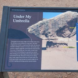
Thousands of years ago a huge rock boulder broke from the cliff above and tumbled to a stop here. The hard conglomerate boulder compressed the softer dirt directly beneath, making it resistant to erosion. The boulder also acted as a massive umbrella, protecting the stone beneath from years of wind and rain. Over time, at least 6 feet (2.8 m) of the surrounding loose ground was carried away, leaving an ever-crowing pedestal with a balanced rock perched on top. You can see this process taking place under many rocks in the area. At some point, the sheltering boulder may become too much weight for its pedestal, toppling and taking another fateful tumble.
Time:
Fees: Park Entrance
Recommended Ages:
 | 0-3 |
 | 4-11 |
 | 12-19 |
 | 20-49 |
 | 50-69 |
 | 70+ |
Recommended Months to Visit:
| Jan |
| Feb |
| Mar |
| Apr |
| May |
| Jun |
| Jul |
| Aug |
| Sep |
| Oct |
| Nov |
| Dec |
Navigate to 36.841421, -111.631763.
Closest City or Region: Glen Canyon National Recreation Area
Coordinates: 36.841421, -111.631763
By Jeremy Dye
Jeremy Dye, Tara Dye, Ondylyn Wagner, Shawn Parker, Marci Parker, Becca Bevan,
We stopped at the roadside pullout so I could jump out and take a few pictures for this blog. We then shared the information while driving.
Camping at Halls Creek and Millers Creek Confluence
Escalante River Primitive Camp 1
Escalante River Primitive Camp 2
Fence Canyon Primitive Camping
Iceberg Canyon Primitive Camping
Navajo Canyon Primitive Camping
Stud Horse Point Primitive Camping
Baboon Laughs Canyon (aka Laughing Baboon Canyon)
Poe Canyon (aka Smiling Cricket Canyon)
Early Weed Bench to Escalante River
Escalante River to Early Weed Bench
Lee's Ferry Historic District River Trail
Navajo Bridge Interpretive Center
Stud Horse Point Primitive Camping
Vermilion Cliffs National Monument
Buckskin Gulch and Paria Canyon from Wire Pass to Lees Ferry
Lee's Ferry Historic District River Trail