

Hype:
The Shakespeare Arch/Sentinel Trail used to be one of the most interesting trails within Kodachrome Basin. However in May 2019, Shakespeare Arch collapsed. Shakespeare Arch was the only significant arch in Kodachrome Basin State Park.
Trail Condition: Class 2 (Trail may have tree roots or rocks jutting out. Navigation skills may consist of following rock cairns and choosing turns at junctions. Elevation gains may be more substantial.)
Time: 45-90 minutes
Length: 1.5 mile loop
Elevation Gain: 200 ft
Fees: Park Entrance
Recommended Ages:
 | 0-3 |
 | 4-11 |
 | 12-19 |
 | 20-49 |
 | 50-69 |
 | 70+ |
Recommended Months to Visit:
| Jan |
| Feb |
| Mar |
| Apr |
| May |
| Jun |
| Jul |
| Aug |
| Sep |
| Oct |
| Nov |
| Dec |
Navigate to 37.510744, -111.978229.
Park in the parking area at the end of the spur road.
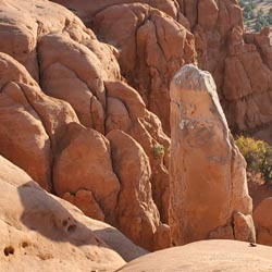
From the trailhead, head west over the ridge. The trail then bends southwest and you follow along the base of the ridge. You'll soon come to the remains of Shakespeare Arch. Continue southwest, contouring around the boulders until you pass The Sentinel, a lard sand pipe. Continue south and take an optional spur trail to a viewpoint overlooking the region. The trail then wraps around the south end of the ridge and turns north. At the trail junction, you can choose to continue on the lower trail to take a left to short climbs that takes you down the slickrock bypass. Both routes are about equal lengths and join up just before the parking area.
Closest City or Region: Kodachrome Basin State, Utah
Coordinates: 37.510744, -111.978229
Shakespeare Arch/Sentinel Trail
Skutumpah Road Primitive Camping
Shakespeare Arch/Sentinel Trail
Bryce Canyon National Park Visitor Center
Bryce Canyon Wranglers at Ebenezer's Barn and Grill