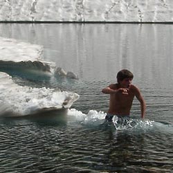


Hype:
The Mount Timpanogos trail has to be the most popular hike in Utah County - and for good reason. The entire length of the trail is surrounded by rugged beauty.
Trail Condition: Class 2 (Trail may have tree roots or rocks jutting out. Navigation skills may consist of following rock cairns and choosing turns at junctions. Elevation gains may be more substantial.)
Time: 4-12 hours
Length: 13 miles round trip
Elevation Gain: 5,800 ft
Fees: Per Vehicle, Interagency Passes are Accepted
Recommended Ages:
 | 0-3 |
 | 4-11 |
 | 12-19 |
 | 20-49 |
 | 50-69 |
 | 70+ |
Recommended Months to Visit:
| Jan |
| Feb |
| Mar |
| Apr |
| May |
| Jun |
| Jul |
| Aug |
| Sep |
| Oct |
| Nov |
| Dec |
Navigate to 40.404671, -111.605255.
By Jeremy Dye
Jeremy Dye, Tara Dye, Ondylyn Wagner,
Start: 11:20 a.m.
Peak: 5:30 p.m.
Finish: 10:20 p.m.
We got a really late start because we were sick and wanted to sleep in. Ondy had sprained her ankle two months previously. She was doing fine until she stubbed her toe on a tree root on the way day. After that, it was causing her a lot of pain, so we took it really slow for the last couple of miles. The weather was warm in the day and chilly after the sun went down. When we were at the pond, we sat and talked with one of the volunteer medics that was camped there for the weekend. They said that the glacier was nearly vertical at the top and there was no safe way down with all the boulders, so we decided not to slide down the glacier this trip.
By Jeremy Dye
Jeremy Dye, Anthony Dye, Ondylyn Wagner, Hyrum Griffin, Melissa Griffin, Jenny McBride,
In July 2004, I went again.
East Portal Dispersed Campground
Hidden Peak, Mt Baldy, and Sugarloaf Mountain
Mount Timpanogos Trail from Aspen Grove
Timpooneke Trail to Mount Timpanogos
Logan Ranger District Visitor Information Center